
THE CAMINO PRIMITIVO
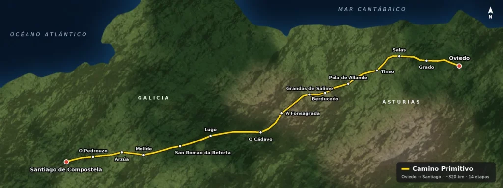
The Camino Primitivo was the original pilgrimage route to Santiago, the one followed by King Alfonso II of Asturias when he began the tradition in the XNUMXth century, shortly after the discovery of the apostle's tomb. Pilgrims who choose to follow this route will walk along the same paths the king trod centuries ago, as the current route is similar to that recorded in historical documents.
It's worth noting that, while exceptionally beautiful, this route is more challenging than other Camino routes. The trail crosses the Cantabrian Mountains with continuous ascents and descents. In return, you'll be rewarded with forests, meadows, streams, and small villages where you can sample Asturian cuisine.
Steps
- Oviedo – Grado
- Grado – Salas
- Salas – Tineo
- Tineo – Pola de Allande
- Pola de Allande – Berducedo
- Berducedo – Grandas de Salime
- Grandas de Salime – A Fonsagrada
- A Fonsagrada – O Cádavo
- O Cádavo – Lugo
- Lugo – San Román da Retorta
- San Román da Retorta – Melide
- Mélide – Arzúa
- Arzúa – O Pedrouzo
- O Pedrouzo – Santiago de Compostela
How to get to Oviedo
Oviedo is the capital of the Principality of Asturias, and as such, it is well connected, both by train and by road and even by plane.
- By trainThere are daily trains from Chamartín station in Madrid. The journey takes about three and a half hours.
- By roadOviedo and Asturias are connected to the rest of the Peninsula by the A-66 and A-8 motorways (Autovía del Cantábrico).
- By planeAsturias Airport receives flights from all over Spain. Please note: the airport is located in Anzu, about 50 minutes from Oviedo, so you will need to take a car or bus once you arrive there.
Remember our taxi service It is available to take you to Oviedo, or to your home once you have finished your Camino.
Steps
Stage 1: Oviedo – Grado (25 km)
Distance: 25 km · Difficulty: Medium
We begin our route at the Cathedral of San Salvador in Oviedo. Although leaving the city is straightforward, the climbs towards San Lázaro de Paniceres and El Escamplero will give us a first taste of the mountainous nature of the route.
After crossing the Nalón River in Peñaflor, a final climb takes us to Grado, a town with a good atmosphere and all services.
Stage 2: Grado – Salas (22 km)
Distance: 22 km · Difficulty: Medium
We begin with the first serious challenge: the climb to Alto del Fresno, from which we can enjoy a beautiful view of the valley. Afterwards, we'll descend towards Cornellana, where we can visit the Monastery of San Salvador, one of the historical landmarks of the Camino Primitivo.
The final stretch runs through forests and meadows until reaching Salas, a medieval town that stands out for its historical architecture, such as the tower and the Valdés-Salas palace.
Stage 3: Salas – Tineo (20 km)
Distance: 20 km · Difficulty: Medium-high
Although this stage is short in distance, the climb from Salas to La Espina is going to be tough. The landscape changes from riverside forests to more open and clear areas; the Bodenaya albergue is a very popular stop for pilgrims.
After La Espina things will get easier until we reach Tineo, where we can enjoy the Pedro de Tineo walk with views of the Asturian valleys.
Stage 4: Tineo – Pola de Allande (27 km)
Distance: 27 km · Difficulty: Medium-high
This is a long, mid-mountain stage that traverses some of the Camino's most secluded landscapes, with a stop in Campiello to refuel. Before reaching Campiello, there's a detour we can take to visit the Monastery of Santa María la Real de Obona.
Upon reaching Borres, we will have to choose between two options: descend to Pola de Allande via the main route or take the Ruta de los Hospitales (Hospital Route), a more challenging and exposed route that leads directly to Berducedo. The latter is only recommended in good weather.
Stage 5: Pola de Allande – Berducedo (18 km)
Distance: 18 km · Difficulty: High
We have reached the most difficult stage of Camino Primitivo: the climb from Pola de Allande to Puerto del Palo, located at over 1.100 meters altitude, is a challenging one. The visual reward from the summit is incredible, although you need to be prepared for sudden changes in weather.
After the port, we will descend, crossing the villages of Montefurado and Lago (famous for its ancient yew tree) until we reach the picturesque village of Berducedo.
Stage 6: Berducedo – Grandas de Salime (20 km)
Distance: 20 km · Difficulty: High
After passing through La Mesa, one of the steepest and longest descents on the Camino begins, leading to the Salime reservoir. It's a visually stunning stretch, but demanding on the knees.
After crossing the reservoir, we will climb again until we reach Grandas de Salime, an important Asturian town with a well-known ethnographic museum.
Stage 7: Grandas de Salime – A Fonsagrada (25 km)
Distance: 25 km · Difficulty: Medium-high
This mountain stage offers a gradual ascent through typical landscapes such as the Chao Samartín "castro" (fort hill). After passing through the Puerto del Acebo pass, surrounded by windmills, we will enter Galicia. We continue along the route until we reach A Fonsagrada.
Stage 8: A Fonsagrada – O Cádavo (24 km)
Distance: 24 km · Difficulty: Medium-high
This is a mountain stage with continuous ascents and descents. Halfway along the route, we come across the ruins of the Montouto Hospital, a former pilgrim refuge in a solitary and beautiful setting.
We have a steep descent ahead of us, towards Paradavella, and another tough climb to A Lastra and Alto da Fontaneira. From there, the path descends gently to O Cádavo Baleira, a small village with the necessary amenities.
Stage 9: O Cádavo – Lugo (30 km)
Distance: 30 km · Difficulty: Medium
We face the longest stage of the Camino Primitivo, although in compensation, the terrain is somewhat easier than in previous days. The route passes through Castroverde and leaves the mountains, following rural tracks and small villages until reaching Lugo.
We entered the city of Lugo through the San Pedro Gate in its Roman walls, a UNESCO World Heritage Site. It's well worth exploring the city on foot and visiting the cathedral. Many pilgrims stay here for a day of rest.
Stage 10: Lugo – San Román da Retorta (19 km)
Distance: 19 km · Difficulty: Low
After crossing the Roman bridge over the Miño River, the route becomes flat and easy across the Lugo plateau. This is the ideal stretch to recover your legs after days in the mountains. You can take a detour to Santa Eulalia de Bóveda to see its mural paintings before arriving at San Román da Retorta. NOTE: this village has limited services, so plan your accommodation carefully.
Stage 11: San Román da Retorta – Melide (28 km)
Distance: 28 km · Difficulty: Medium
A long but gentle route, surrounded by oak forests and Galician countryside. A highlight is crossing the medieval bridge over the Ferreira River. In Melide, the path joins the Camino Francés, where the atmosphere changes and we can enjoy the famous pulpo á feira.
Stage 12: Melide – Arzúa (14 km)
Distance: 14 km · Difficulty: Medium
Following the route of Camino Francés, we crossed eucalyptus and oak forests, going up and down river valleys. A highlight was passing through Ribadiso da Baixo, with its medieval bridge and riverside hostel, before the final climb to Arzúa, the capital of Galician cheese.
Stage 13: Arzúa – O Pedrouzo (19 km)
Distance: 19 km · Difficulty: Low
Finally, a comfortable stage, a prelude to reaching our destination. We'll find plenty of rest stops, bars, and all kinds of services, and we can enjoy the Galician villages and eucalyptus forests.
O Pedrouzo is the last usual stop before Santiago; many pilgrims choose to rest here early to prepare for the grand finale the following day.
Stage 14: O Pedrouzo – Santiago de Compostela (20 km)
Distance: 20 km · Difficulty: Low
On our final leg, we'll cross through forests and walk alongside Lavacolla Airport. After climbing Monte do Gozo, we'll see the Cathedral towers on the horizon for the first time. Then it's just a descent to Obradoiro Square.
